




And now for some not-so-happy news from a not-so-happy map.
You know that whole thing about how Manhattan is an island? Right. This map shows what would happen if sea levels rose just twenty feet within the next century.
Basically, it doesn't look too good for us.
The Surging Seas map created by Climate Central below renders what would occur if global temperatures rose by approximately two degrees, which would raise the sea levels by about twenty feet.
If this happens, lots of New York City would be completely flooded. This means submersion for JFK Airport, Hunts Point Produce Terminal, LaGuardia Airport, and most of Rikers Island.
There is some good news, though. Bjarke Ingels, the famed architect slated with the job of designing the World Trade Center's final skyscraper, has a project in the works that will protect the "Dry Line," a ten-mile area in lower Manhattan, which include reconfiguring park spaces and installing deployable walls.
Thankfully, those plans are currently under-way.
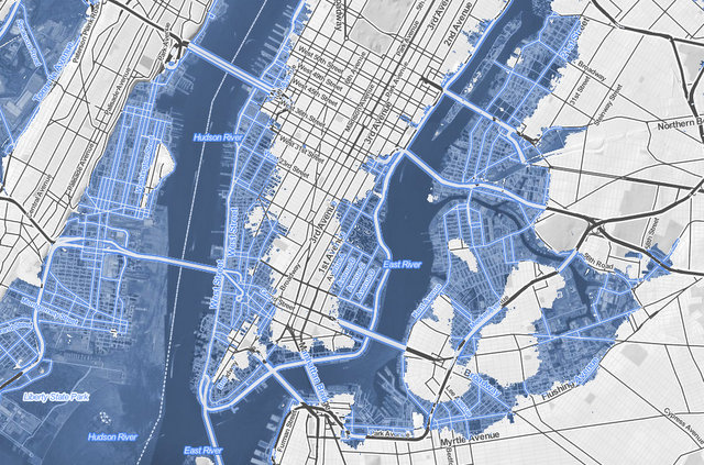
via Climate Control
Also, a lot of organizations are at work planning right now, as they compete in a Rebuild by Design competition put on by the U.S. Department of Housing and Urban Development, the New York City's Vision 2020 plan, and the Metropolitan Waterfront Alliance.
These plans will take into account new waterfront edge design guidelines, which will hopefully protect Manhattan from rising sea levels in the decades to come.
Check out All Those Commuters Really Cause a Helluva Increase in Manhattan's Population, Huh?!